Hi everyone! It's been nearly a month since my last post, but I've been traveling since getting off the Ice. So much to talk about and TONS of pictures for all of you.
But first thing is first: the winner of the pub trivia challenge! I'd like to start out by saying that when I posted the biology trivia questions I was expecting I'd get responses from very few people. In fact, I expected responses from just three or four people. Turns out I was bang on. Three people participated, and they were exactly who I thought they would be. Those three people, (you know who you are), thanks for playing! You all did really well! The scores: RRR with 30 points, RR with 34, and KW with 41. The scores were really close and there were only three of you so you'll all be getting something! I'll be in contact to talk about your prizes. :) For those interested, here are the answers:
• 1. a) 1 point for having ”1” bone. b) 1 more point for the name ”hyoid bone.”
• 2. a) 1 point for ”nephron”. b) 1 point for ”juxtamedullary nephron”.
• 3. 64 days. (1 point for any answer between 54 and 74).
• 4. Endoderm, Mesoderm, Ectoderm
• 5. a) Cervical vertebrae, Thoracic, Lumbar. b)cervical (7), Thoracic (12), Lumbar (5).
• 6. a) Myelin sheath (layer) I’ll also accept Schwann cells (PNS) or oligodendrocytes (CNS). b) Primary role is to speed up conduction of impulses down an axon by reducing surface area of uninsulated axon to periodic nodes. Instead of propagating continuously down the axon, nerve impulses hop across the insulated axon to uninsulated nodes, dramatically increasing the speed of propagation.
• 7. Cytoskeleton, ER or Endoplasmic Reticulum (if separated into smooth and rough ER, I’ll accept it as 2 points), flagellum (plural flagella), Golgi Apparatus, Mitochondria, Vacuole, Nucleus, Acrosome, Autophagosome, Centriole, Cilium (pluaral cilia), Lysosome, Melanosome, Nucleolus, Myofibril, Peroxisome, Ribosome, Vesicle. 19 possible points! (I admit I missed a few myself... :( )
• 8. a) Among other differences, rods allow us to see in black and white, while cones gives us color vision. b) Cones are most highly concentrated on the back of the retina, near the optic nerve, specifically in a patch called the "Fovea Centralis" or just "Fovea."
• 9. The diaphragm.
• 10. cerebellum
• 11. Hypothalamus
• 12. a) 23. b) 21. c) Chimpanzee (48, while a human has 46 total chromosomes).
• 13. a) Cellular mitosis and meiosis. b) Mitosis leaves both daughter cells with complete copies of each chromosome. Meiosis gives each daughter cell (4) a copy of only one chromosome in a pair.
• 14. Starches (carbohydrates) and fats (lipids) (1 point for each).
• 15. ATP (adenosine triphosphate)
• 16. a) amino acid. b) 3. There are 4 base pairs. There are 20 standard amino acids the body produces, so you need at least 20 distinct combinations. 4^2 = 16, so you need at least 3 base pairs to have enough combinations (64) c) Lysine. d) AAA or AAG (adenine, guanine) (no cytosine or thymine[uracil])
• 17. Pinna (or auricle)
• 18. Dura Mater
• 19. Corpus Callosum
• 20. sphygmomanometer
• 21. Phospholipids.
• 22. Cochlea.
• 23. Semicircular Canals.
Thanks again to Mrs. Iler for being such an amazing biology teacher in high school!
So, what have I been doing the past few weeks? Well, two nights before leaving the Pole we all decided it'd be a shame to be in Antarctica without watching John Carpenter's The Thing, so Thursday Feb 2 that's exactly what we watched. Nothing like a good horror/thriller to make you feel uncomfortable about where you sleep. The following night, my last night at Pole, we watched the new prequel of The Thing. It's all about the Norwegian camp that finds the Thing, and the end of the movie ties into the beginning of Carpenter's version quite nicely. The camera was working (albeit it still needs some optimization), the receiver team's job was essentially done, so it was a nice way to say goodbye to the South Pole.
Earlier that day I went out to DSL and the telescope one more time to help with a bit of clean up and to say goodbye to SPT. I decided to take a video of the telescope moving so here it is. The video is of SPT moving from inside the control room, directly under the dish. The telescope is almost entirely silent from outside - all you can usually hear are the pulse tube coolers pulsing helium gas back and forth (the higher pitched chirping in the video). I have other videos, from outside so you can see the dish moving, but they're too big to upload to blogger. If you're interested I can post they somewhere else.
In the receiver lab one last time... :(
|
Later that evening (but before the movie) we had to bag drag. We took all of our stuff out to Summer Camp to get weighed and palletized to be loaded up on the LC-130 the following day. On the way back we thought it'd be fun to take a funny picture, so this is Liz pretended to be dead on the ground in front of the station. She's fine, by the way.
Liz was complaining that the ground was really cold and that I was taking too long to get my camera out.
|
The following day (Saturday the 4th) we flew out. Generally when you leave the Pole you stay at least a day in McMurdo again waiting for the first C17 flight back to Christchurch. We were lucky though, and Feb 4th was the first "straight-through" flight for the season. Everything is scheduled such that when you get to McMurdo a C17 has already landed or is on its way so you only have to wait a couple hours. We left the Pole around 11:30 AM and landed on Pegasus airfield some time in the early afternoon. Our C17 wasn't going to land for an hour or so so we had some time to kill.
The LC-130 on the runway at the South Pole about to take me home being loaded up with cargo before we all got on.
|
One last look at SPT in the distance before boarding.
|
Back on the Antarctic coast: Mt. Erebus in the background, this time after returning from the Pole.
|
While roaming around we all had quite a treat. Apparently a lone penguin had wandered into the area and we all grabbed our cameras for a chance to see one in its native Antarctica. And there it was, just around the corner, laying down and then eventually standing and grooming itself. Here's a picture of me in front of it. Perhaps too close, but it didn't seem to care. I was really lucky to see one too as this was my first time but it was the third time down for Abby, Liz, and Jon and their first time seeing a penguin too. It was definitely the cherry on top of a fantastic experience.
A lone penguin hanging out at Pegasus Runway. It's posing well for the camera. Thanks, penguin!
|
The C17 had just landed and it was beginning to be loaded up with cargo for the trip back to Christchurch and civilization.
|
I remember while on the plane looking out the window and suddenly realizing it was getting dark out... I hadn't seen nighttime in two months so it was a little bizarre. It really started to sink in that I was actually leaving! And then the ride was over. We got back to Christchurch around 11:00 PM that night, dropped off all of our ECW gear, and headed to our respective hotels for some sleep. The next day I met up with Liz and Jay for some hiking adventures in New Zealand! We rented a car (I found driving on the left to be really comfortable once I get used to sitting on the other side of the car while driving), we bought some gear (I needed a sleeping bag and a rain jacket, for example), and we drove off for the northwestern part of the south island for our first day of tramping.
So, there we were, our second day off the ice and in the middle of nowhere New Zealand, in
Kahurangi National Park. Our objective: hike in to a backcountry hut, stay the night, and then climb to the summit of Mt Owen (1875 meters), then hike out. Total trip between two and three days, depending on how long it took us to reach the summit on day two. It's probably better just to show you tons of pictures with captions, so here they are:
 |
| The start of our tramping in New Zealand. It was raining, but the views were already pretty nifty. |
 |
| Not too far into our hike the clouds looked like they were starting to break up and we could start seeing some things across the valley. |
 |
| As we headed up the ridge we entered this spooky looking forest. All the rain and mist made for some incredible scenery, even if we didn't have views of all the neat stuff across the valley from us. |
 |
| Eventually we made it out of that forest, had lunch in a clearing, and found this forest. But this one had cool tree beard moss. Nice! |
 |
| In the afternoon the clouds were starting to burn off and we started getting glimpses of Mt Owen and the surrounding mountains. |
 |
| We headed down into this river valley. The next step was to go down this really steep part called the Staircase and the then boulder our way up the river bed towards the hut where we'd be staying the night. |
 |
| Having finally made it to the hut, I took some photos of the view from where we'd be staying that night. Here's the view looking east. |
 |
| The hut was in the middle of no where. |
 |
| See. The middle of no where. And all the better for it. |
 |
| Looking back at the hut and the Tyrannosaurus shadow about to eat it. It was the end of our first day of hiking in New Zealand but already we could tell this place was an incredible mixture of Lord of the Rings and Jurassic Park. The island felt so primeval and otherworldly. |
 |
| Heading up to Mt Owen the following day. You might notice a helicopter parked on the grass right below the mountain. Someone had paid to get dropped off as the base of the mountain so he could climb the rest of the way up with his wife for their 25th wedding anniversary. We learned from the pilot that this location was used in Lord of the Rings. Remember when Gandalf falls in Moria and the Fellowship comes out and mourns his death on the rocks? That's this place. I didn't know that before, so I was really excited! The filming crew were all helicoptered in. We hiked for a day and a half to get here. Much cooler. |
 |
| Mt Owen panoramic. Photo by Liz George. |
 |
| These tarns (lakes) were the last place to get water on the way up the mountain. We had brought plenty of our own, though, so we skipped them by. It turns out, though, that through much of New Zealand the lake and river water is perfectly safe to drink right there. No nasty bugs to give us upset stomachs. |
 |
| Climbing Mt Owen. You can see some amazing stuff from the road in New Zealand, but you can't see this! |
 |
| Oh, look, Sam crying! Oh, wait.... |
 |
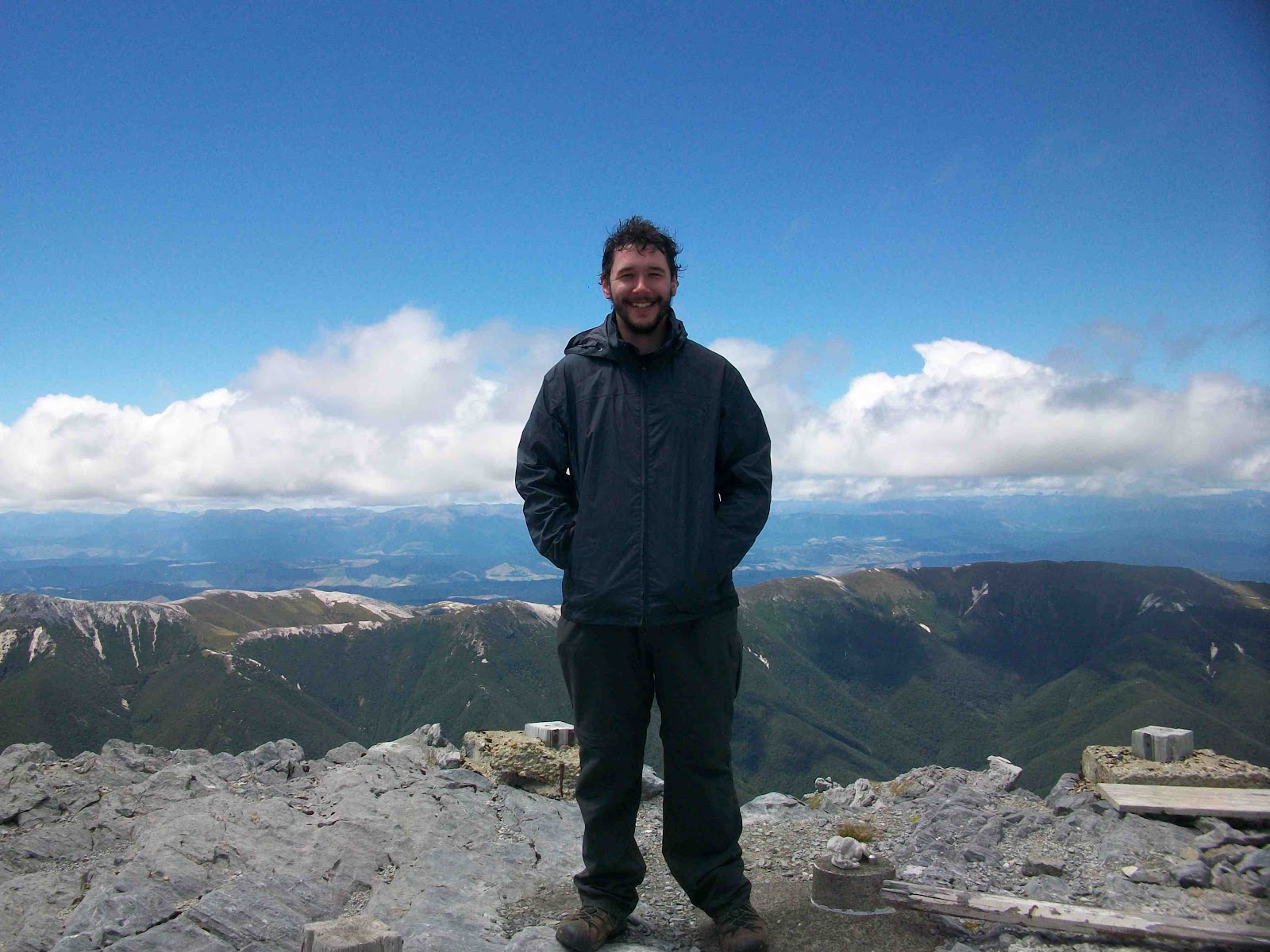
| Me at the top of Mt Owen. The view was absolutely fantastic. |
 |
360 degree panoramic of the view from the top of Mt Owen. Photo by Liz George.
|
 |
| Coming down Mt Owen. Pictures just don't do any of this justice. |
 |
| These limestone crevasses were everywhere. Unlike Liz here, I stayed clear of the edges. |
 |
| Jay was okay with the crevasses too. I walked across that too, but I stayed in the middle, thank you very much. |
After climbing down Mt Owen all of our knees were really sore (we hiked up and came all the way back down to our car the same day). We decided we needed a "day off" and drove a couples hours north to the northern shore and Abel Tasman National Park. There we decided to do a short half-day hike around a peninsula in the park. Some photos:
 |
| Me on the Abel Tasman Trail, on the north coast of the south island on our day off between the Mt Owen and Avalanche Peak hikes. |
 |
| There were cicadas everywhere, and this one was still moving before the spider got to him. Photo by Liz Georege. |
 |
| Going up on the Abel Tasman trail. |
 |
| We stopped for lunch on the beach. |
 |
| The high point of our hike to Separation Point on the Abel Tasman trail. It was getting late so we decided to head back after this. |
 |
| It was low tide by the time we got back down the hill. |
After Mt Owen and our day off hike on the north coast of the island, we headed to Arthur's Pass to do a two-day hike. Day one was hiking to the summit of Avalanche Peak then hiking back down the other side to stay the night in Crow Hut, in the Crow river valley. The next day was hiking back out along the river valley. More pictures tell the story:
 |
| The first part of the Avalanche Peak hike was this crazy steep section that took us 90 minutes or so to get through. We were literally using tree roots to pull ourselves up. But we saw this waterfall on the way. |
 |
| After 90 minutes of pretty ridiculous rock scrambling and climbing, we popped out of the trees to look at the valley. |
 |
| Above the tree line the weather started getting nasty as we headed into a cloud. It was also starting to get pretty steep on either side of us. I'm not too great with heights, so I was starting to get nervous. But no other choice than to keep moving and hit the summit as we had to get back down on the other side before it got dark. Photo by Liz George. |
 |
| Right before the Avalanche Peak summit was this 20m stretch of knife edge ridge we had to cross. Definitely a life experience for me. The guidebook said to not attempt this hike on a bad weather day as it could be very dangerous. Ah, this must be why. On top of everything being damp and being one slip away from a painful death, the wind was absolutely howling. And here I am afraid of heights with a big pack on my pack to knock me off balance... great... but, hey! Have to keep moving to get down before dark, so no choice but to keep putting one foot forward. Photo by Liz George. |
 |
| The knife edge ridge and the peak behind us, we head down the ridge I'm walking over in this picture to reach a scree field that we have to go down in order to reach Crow Hut, which is down on my left at the bottom of a river valley. Photo by Liz George. |
 |
Continuing down the ridge towards the scree field. There were scree fields all over the place, but most of them ended in bluffs hundreds of feet above the river, so it was important we found the RIGHT scree field to go down... again, before dark.
 |
| Just before reaching the scree field we spotted the hut we would eventually get to way down below. See the red roof?Photo by Liz George. |
|
 |
| The right scree field! Scree is loose rocks and pebbles and we literally had to surf and slide our way down it. Don't twist or break an ankle now! |
 |
| At the head of the river valley was a glacier feeding the river. |
 |
| One way we could tell we had found the correct scree field was that Punchbowl Falls was in full view for the first time on the other side of the ridge. Can you see the punchbowl and the waterfall emptying it? |
 |
| Liz got down to the bottom first, as Jay and I had no scree experience. The scree field was about a kilometer long (about half a mile). To get some sense of scale, I'm the black dot below left of center, and I'm about 3/4 of the way down at that point. It took me an hour to get all the way down. Photo by Liz George. |
 |
| Made it down the scree field! And just in time for a spectacular sunset. That meant navigating this rocky river bed in the dark in order to find the hut. But we found it! |
 |
| After a night in Crow Hut, we started hiking down the river and out of the valley to get back to our car. Photo by Liz George. |
 |
The hike out of Crow Valley was 4 hours of climbing back and forth across rocks and this river. Here's Jay trying to pick out the right rocks to leap frog across on. Photo by Liz George.
 |
| Yeah, we're in New Zealand. No biggie... Walking out of the Crow river valley after our night in Crow Hut on our Avalanche Peak hike. Photo by Liz George. |
|
 |
| Later that same night we were back in Christchurch and I'm 10 weeks in to growing my beard. 10 weeks, and that's all I had! Well, beards aren't for everyone and it was really starting to drive me nuts, so I shaved it off right then and there. |
The following day Jay needed to be in Christchurch to fly up to the north island for a couple days before he returned to the States. Liz and I had a few more days to burn before I was to meet my girlfriend in Christchurch, so we decided to drive to Mt Cook National Park and do some more hiking in that area. More pictures:
 |
The next day we dropped Jay off at the airport so he could spend a couple days on the north island. Liz and I drove to Mt Cook national park for 2.5 more days of hiking. This is me (cleanly shaven for the first time since the end of last November) in front of Lake Pukaki. The eerily opaque light blue color of the lake is from silt washed down from the glacier that feeds the lake. I later learned that two different sites along lake Pukaki were used in filming for the Hobbit, so keep your eyes peeled for this weirdly blue lake!
|
 |
| Looking out the glacier valley that eventually ends in Lake Pukaki. We're now 50 km up the road right against the edge of the glacier. |
 |
| This range of mountains had glaciers everywhere. The rest of our half day hike was to get closer to these mountains and get a better look of Mount Cook, the highest peak in the south island. |
 |
| We crossed over two rope bridges on our way to the Hooker Glacier, the glacier that carved this valley (the second glacier/valley we hiked up that day). The first bridge is just visible here on the right. |
 |
| Approaching the second rope bridge. |
 |
| The end of our hike. Directly in front of me are icebergs coming off of Hooker Glacier, which is the dirty looking thing in the middle of the photo. Mount Cook, looking all mountainy, is in the far background. |
 |
| Me in front of Mount Cook. I was there! |
 |
| The next day we started our climb to Mueller Hut. It's a hut on a mountain ridge directly across a valley from the mountains with all the crazy glaciers. This is our first view of them that day after having climbed 2.5 hours through the clouds. In the far background you can see some weather pouring over the mountain range. It spilled over like that all day. It was quite something to watch. |
 |
| The sea of clouds we climbed through on our way to Mueller Hut. |
 |
| On our way to the hut. We're about level with the glaciers now! |
 |
| As we climbed a bit higher the clouds started breaking up a bit, giving us a glimpse of the town we started at earlier that morning. |
 |
| 3.5 hours in, we saw the hut! Time to relax and take a nap in the sun! |
 |
| The view of Mt Cook from Mueller Hut. |
 |
| Later that afternoon I hiked up just a bit past the hut to get a shot of it with the mountains and crazy glaciers. Pretty cool place to spend a day/night. |
After Mt Cook Liz and I headed back to Christchurch. I was meeting my girlfriend Caitlin at the airport on Tuesday the 14th for one more week in New Zealand. Caitlin and I saw quite a bit and drove all over. Here are even MORE photos:
 |
| I was lucky enough to have my girlfriend Caitlin meet me for my second week in New Zealand. Here we are arriving in Queenstown after a long day of driving (on the left side of the road). We came to Queenstown to see Milford Sound the following day. |
 |
| On our way to Milford Sound we stopped off to take a look at this spot, called the Chasm. It's this giant hole in the ground cut by a river. Large cylindrical holes in the rock were etched out over millennia as grit and stones in the water were caught in eddies. You can see stuff like this near Niagara Falls, actually. |
 |
| We took a boat ride down Milford Sound. Most of the pictures didn't turn out all that great as it was cloudy and windy. But towards the end of the boat ride we approached this waterfall, so I snagged a few photos of it. |
 |
| Heading back to the docks, the sun finally started peaking through the clouds on Milford Sound. |
 |
| Sunset in Queenstown after our tour of Milford Sound. |
 |
| The next morning before heading back to Christchurch we took a gondola ride up to a ski lodge on the hill overlooking Queenstown. There's the town below us. That yellowish brown hill in the middle of the shot is Deer Park Heights, a filming location for several scenes in the Two Towers. |
 |
| A better view of Queenstown. |
 |
| Instead of driving along the plains on our way back to Christchurch we took the long way back, up the west coast of the island. We stopped where the road got really close to the ocean. This is the Tasman Sea. Somewhere out there is Australia and Tasmania. |
 |
| Further up the road there was a quarter mile or so of beach with all these rocks that had been left with messages to loved ones. I thought it was a really cool idea. Unfortunately, we didn't have a marker to leave a note ourselves. Maybe next time. :) |
 |
| Just before it got dark we stopped off at the Franz-Joseph glacier. This was used in the lighting of the beacons sequence during Return of the King. Cool! |
 |
| My last day in New Zealand Caitlin and I took a tour of Mt Sunday, the filming location of Edoras in the LOTR movies. Can you see it in this shot? It's the lonely hill in the middle separated from all the mountains. |
 |
| Hiking up to the top of Edoras, our tour guide pointed out something in the background. See that little stand of trees on the edge of the mountains just left of center? That valley right behind it was used as the external shot for Helm's Deep. Aragorn came riding up on his horse and sat looking at it from one of the hills in the right of the picture. Of course, Helm's Deep was added digitally - the battle at Helm's Deep was filmed in a quarry outside of Wellington on the north island, but seeing the entrance to Helm's Deep was still pretty cool! |
 |
| I'm standing on Edoras! Right where the Golden Hall of Meduseld was! The rocks you see on the right were underneath the steps at the front of the hall to give you some sense of where things were. They weren't allowed to modify the summit of Mt Sunday so they had to build everything up on top of the rocks that were already there. I'm standing on the highest point of the hill, a boulder that sticks up a foot or so higher than boulders around it. This forced the ground floor of the Golden Hall to be as tall as it was. Go back and check it out. There's a good three feet of stone foundation underneath the Hall - that's because of the boulder I'm standing on. |
 |
| The guide had Caitlin recreate a scene in the movie. Remember when Eowyn is standing on the steps looking out across the plains at Aragorn, Legolas, and Gandalf arriving. That's the shot. If you go back and look, the scree field behind Caitlin's head is the same scree field behind Eowyn's head. Neat! |
 |
| Notice the green path (which soon becomes a yellow path) down there? That was where the path was that people took during the funeral scene in the Two Towers down from Edoras to the funeral mounds. The path starts where the wall and gate to Edoras were built. The two rows of mounds at the end of the path are the funeral mounds of all the old Rohirrim kings. |
 |
| The low hills behind the picture the guide is holding are where Aragorn and Gandalf sat when looking at Edoras for the first time. I was totally geeking out on this tour. Loved it. |
 |
| One last look at Edoras on our way back. Such an amazing location! All that's left now, though, are cows. At least it lives on in film. |
Well, that's all I have. It's really the end of my adventures as I'm back in the States and starting to plug back into research. But I'm sure I'll have one or two more posts in the future to update everyone on how SPTpol is doing, but I'm not sure when they'll be posted. So consider this the last post. Thanks to everyone who have been following, and I hope you've had a good time. It's been fun!
-Jason